Picture this: you’ve been driving for hours across the wide-open Texas panhandle, the horizon flat and endless, the sky enormous. Then New Mexico begins to rise around you. The piñon trees appear. The Sangre de Cristo Mountains crest the horizon. And when you finally roll into Santa Fe, past adobe walls glowing warm in the afternoon light, you understand exactly why the people who built Route 66 made sure it came here first.
This year, 2026, marks 100 years since Route 66 first opened its lanes to America. Across eight states, travelers are hitting the Mother Road in record numbers to celebrate a century of open-road adventure. And while the route that millions know today bypasses Santa Fe entirely, the original 1926 alignment told a different story. Santa Fe was right at the heart of it — and the politics that removed it from the map make one of the best tales in American road history.
Whether you’re driving from Amarillo, planning the original Santa Fe Loop, or simply wondering whether the detour is worth your time, this guide answers every question and helps you turn your Santa Fe stop into a real stay.
🛣️ Santa Fe and Route 66: A Story of Politics, Revenge, and the Open Road
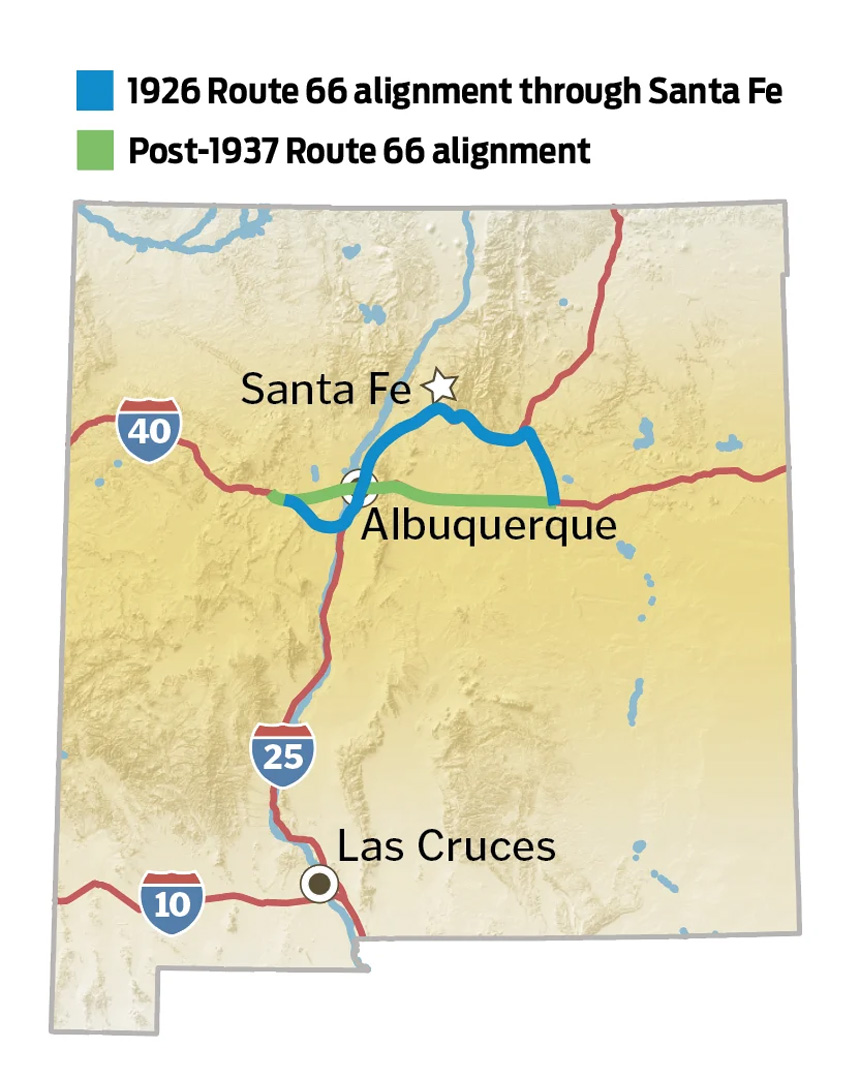
When Route 66 was officially established on November 11, 1926, planners chose an ambitious northward loop through central New Mexico — one that carried travelers right into the heart of Santa Fe, the oldest capital city in the United States. The route followed paths walked, ridden, and driven for centuries before it.
Travelers entered Santa Fe along the Old Pecos Trail, passed San Miguel Mission — the oldest church in the country, its walls dating to 1610 — continued past the Loretto Chapel, crossed the Santa Fe River, and arrived at the historic Plaza and La Fonda on the Plaza Hotel. It was a fitting approach to a city founded by Spanish conquistadors in 1607, long before the first American flag was raised anywhere in the Southwest.
“Get your kicks on Route 66” — the song didn’t mention Santa Fe by name, but the city was there at the very beginning, a jewel on the original alignment before politics changed everything.
So what happened? In 1927, New Mexico Governor Arthur T. Hannett lost his re-election bid. Before leaving office, he ordered the construction of a new, more direct highway connecting Santa Rosa to Albuquerque — completely bypassing Santa Fe. It was widely understood as an act of political revenge against the “Santa Fe Ring,” the business interests that controlled the state capital. The new road opened in 1938, and Santa Fe was cut from Route 66 after just 11 years on the map.
That brief tenure is precisely what makes Santa Fe so fascinating on a Route 66 road trip. A pre-1937 alignment road sign still stands one block from the Plaza, at the corner of Water Street and Old Santa Fe Trail, marking where the original route once ran through the heart of this ancient city.
🗺️ Driving the Santa Fe Loop: The Original 1926 Route 66 Alignment
🤠 Coming In from the East: Amarillo to Santa Fe
If you’re driving the classic Amarillo to Santa Fe stretch, you’re following the original 1926 alignment — the route that first carried America’s cross-country dreamers into New Mexico’s high desert. From Santa Rosa, the pre-1937 alignment breaks north on what is now US-84, climbing through the Sangre de Cristo foothills, cresting the 7,500-foot Glorieta Pass, and descending into Santa Fe with mountain views that no interstate can match. Here are the key stops along the way:
| 📍 Stop | 📏 Miles from Previous | 🌟 What to Know |
|---|---|---|
| Cadillac Ranch Amarillo, TX |
Start | Ten Cadillacs buried nose-first in a Texas field. A public art landmark since 1974 — bring spray paint and leave your mark. |
| Midpoint Café Adrian, TX |
~40 miles | Exactly halfway between Chicago and Santa Monica on Route 66. Classic diner, homemade pie, and one of the most photographed signs on the Mother Road. |
| Tucumcari, NM | ~110 miles | The neon capital of New Mexico. The Blue Swallow Motel, 30+ colorful murals, and the Route 66 Monument make this the classic overnight stop before Santa Fe. |
| Santa Rosa, NM | ~59 miles | The alignment split point — where the pre-1937 route breaks north toward Santa Fe. Stop at the Route 66 Auto Museum and the famous Blue Hole before heading up. |
| Pecos, NM | ~90 miles | Pecos National Historical Park preserves Ancestral Puebloan ruins, a Spanish mission, and the Civil War’s Battle of Glorieta Pass — all along the original alignment. |
| Glorieta Pass | ~15 miles | At 7,500 feet, one of the most dramatic approaches on the entire route. The road crests the pass and begins its descent into Santa Fe with sweeping mountain views. |
| Santa Fe, NM | ~25 miles | The destination. 400+ years of history, a walkable adobe downtown, world-class food and art — and the original heart of Route 66 in New Mexico. |
🏛️ Driving Through Downtown Santa Fe on the Original Route
Once in Santa Fe, you can trace the original alignment right through the city’s historic core. Route 66 entered along Old Santa Fe Trail, passed San Miguel Mission and the Loretto Chapel, arrived at La Fonda on the Plaza, then turned west on Water Street, south on Galisteo Street, and down Cerrillos Road toward Albuquerque. A few stops worth seeking out on foot:
- 🏛️ San Miguel Mission — The oldest church in the United States. Construction began in 1610. Route 66 ran right past it.
- 🔖 Pre-1937 Route 66 Road Sign — Corner of Water Street and Old Santa Fe Trail, one block from the Plaza. Easy to miss, remarkable to find.
- 🍽️ Plaza Cafe — Open since 1905. A Route 66 mainstay when the highway ran past the Plaza. Order the green chile burger at the soda fountain.
- 🛍️ Five & Dime General Store — On the Plaza in the building where Woolworth’s stood during the Route 66 era. The Frito Pie at the snack bar is a rite of passage.
- 🏨 La Fonda on the Plaza — A former Harvey House and one of Santa Fe’s most storied hotels. Route 66 travelers stopped here alongside Georgia O’Keeffe and General Douglas MacArthur.
- 🌟 Cerrillos Road — The original Route 66 motel strip. El Rey Court, established in 1936, still evokes the era with its neon-lit Southwestern-style rooms.
🏔️ Heading South: Route 66 from Santa Fe to Albuquerque
The Historic Alignment — La Bajada Hill
Leaving Santa Fe southbound on the original Route 66, the road first crosses the relatively flat La Bajada Mesa. Then, about 15 miles south of the city, the landscape drops away dramatically. This is La Bajada Hill — “The Descent” in Spanish — and the name understates the experience.
The original alignment descended nearly 500 feet in under two miles via 26 hairpin switchbacks at grades as steep as 28%. Early Route 66 travelers in the underpowered cars of the 1920s and ’30s had to navigate this terrifying stretch before reaching the Rio Grande valley below. Remnants of those switchbacks are still visible from I-25 at Exit 264, or on foot and by 4WD for the dedicated enthusiast. After La Bajada, the original alignment continued through Santo Domingo (Kewa) Pueblo, Bernalillo, and into Albuquerque along 4th Street.
Modern Options: How to Drive This Segment Today
| 🚗 Route | 📏 Distance | ⏱️ Drive Time | ✨ What You’ll See |
|---|---|---|---|
| Interstate 25 | 65 miles | ~1 hour | Fastest option. Follows the historic corridor and offers views of the La Bajada escarpment from the highway. |
| Turquoise Trail (Hwy 14) ⭐ | ~75 miles | ~1.5–2 hours | A National Scenic Byway through Cerrillos and Madrid. Art galleries, live music, and one of New Mexico’s most beautiful drives. Highly recommended. |
| Historic Alignment (partial) | Variable | Half day+ | For dedicated enthusiasts. 4WD required for the La Bajada section. Cerrillos Road through downtown Santa Fe is fully driveable on the original route. |
Local Tip: Take the Turquoise Trail
The Turquoise Trail (Highway 14) through Cerrillos and Madrid turns the Santa Fe to Albuquerque drive from a highway slog into a genuine experience. Madrid — once a ghost town, now a thriving arts community — is a wonderful half-day stop with galleries, restaurants, and live music on weekend evenings.
🎯 Is the Santa Fe Detour Worth It?
Here’s the honest question every road tripper faces at Santa Rosa: do I take the 1926 loop north to Santa Fe, or stay on the faster post-1937 alignment straight to Albuquerque? The detour adds roughly 2–3 hours to your journey. What you gain is completely disproportionate to the time cost.
Most Route 66 stops are places you pass through. Santa Fe is a place you stay.
Here’s what Santa Fe offers that no other stop on the New Mexico stretch can match:
- ✅ 400+ years of history — Founded in 1607, Santa Fe is the oldest capital city in the US. Walking its downtown streets, you move through Native American, Spanish Colonial, Mexican, and American history that no other Route 66 stop can touch.
- ✅ The original alignment is walkable — You can trace the entire Route 66 path through downtown Santa Fe on foot in under an hour. The Plaza, the Water Street sign, San Miguel Mission, La Fonda — all there, compact and extraordinary.
- ✅ World-class food and art — Canyon Road’s gallery district, Museum Hill’s four major museums, the Georgia O’Keeffe Museum, and New Mexico cuisine that will change how you think about green chile.
- ✅ The Turquoise Trail heading south — Leave Santa Fe via Highway 14 through Cerrillos and Madrid and you’re experiencing two Route 66 directions for the price of one detour.
- ✅ A mountain setting unlike anything else on the route — At 7,000 feet, Santa Fe’s high-desert light, piñon-scented air, and adobe skyline give it a quality no flatlands stop can replicate.
We recommend two nights minimum in Santa Fe — three if you want to explore beyond downtown. Here’s how those days fill naturally:
| Day | Theme | What to Do |
|---|---|---|
| Day 1 | The Mother Road | Walk the original Route 66 alignment through downtown. Plaza Cafe for breakfast, San Miguel Mission, the Water Street sign, Five & Dime Frito Pie, sunset drink at La Fonda. |
| Day 2 | Art & Culture | Canyon Road gallery walk in the morning. Museum Hill in the afternoon — four world-class museums in one location. New Mexican dinner on or near the Plaza. |
| Day 3 | The Turquoise Trail | Drive Highway 14 south through Cerrillos and Madrid toward Albuquerque. Breakfast in Madrid, browse the galleries, continue to ABQ or loop back to Santa Fe. |
🏡 Where to Stay in Santa Fe on Your Route 66 Road Trip
After days on the road, a vacation rental changes everything. A full kitchen for breakfast before a long drive. A living room to spread out your maps and road guides. A private space to actually decompress and feel like you’ve arrived somewhere — not just checked in to pass the night. We think that’s exactly what a Route 66 stop in Santa Fe deserves.
We manage two outstanding properties in Santa Fe, each offering something different for the road tripper who wants more than a motel room:
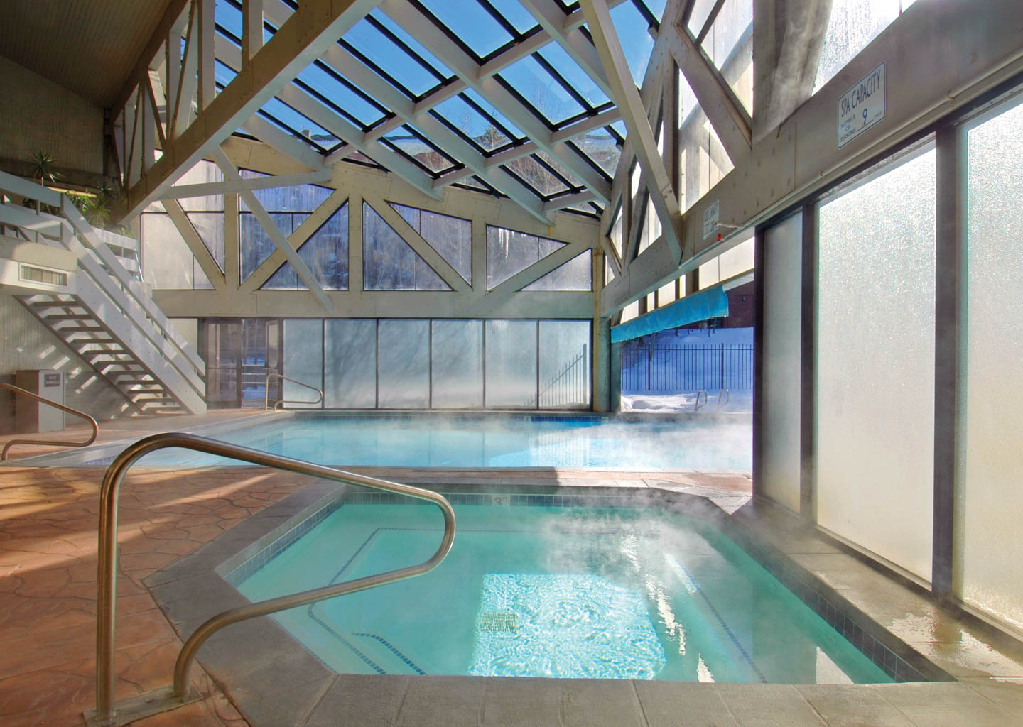
🏛️ Fort Marcy Condos
Steps from the Santa Fe Plaza, next to the Cross of the Martyrs, with lovely views across the city. You’re within walking distance of every original Route 66 landmark in downtown Santa Fe. This is as close to the heart of the Mother Road as you can sleep.
🌿 Quail Run Properties
A gated community with resort amenities — homes, townhomes, and condos offering space and privacy just a short drive from the Plaza. Ideal for families or anyone who wants room to breathe after a long stretch behind the wheel.
Our reservations team is available seven days a week, 9 AM to 5 PM Mountain Time, at 888-575-2775 or reservations@asrlodging.com. We also offer a Lowest Rate Guarantee, a 48-Hour Money-Back Guarantee, and True Blue Perks — a 10% discount for returning guests.
📅 Planning Your Santa Fe Route 66 Visit: Practical Tips
- 🌸 Best time to visit: Late spring (May–June) and fall (September–October) offer comfortable driving weather and thinner crowds. Summer brings spectacular afternoon monsoon storms. Winter is quiet and beautiful, though Glorieta Pass can see snow.
- ⛰️ Altitude awareness: Santa Fe sits at 7,000 feet. Arriving from Amarillo (3,600 ft) or lower, plan for an easy first day. Drink extra water and pace yourself.
- 🗺️ Navigating the old alignment: The pre-1937 route involves frontage roads, state highways, and rural jogs not always marked on GPS. An EZ66 Guide or dedicated Route 66 road atlas is worth having before you leave home.
- 🚗 Amarillo to Santa Fe drive time: Roughly 5–6 hours of driving on the 1926 alignment (~300 miles), not counting stops. Most travelers break the journey with a night in Tucumcari — a classic Route 66 town with genuine neon-lit character.
- 🎉 2026 Centennial events: New Mexico has a full slate of Route 66 Centennial programming throughout 2026. Check with the New Mexico Tourism Department for commemorative events and special activities in Santa Fe this year.
❓ Frequently Asked Questions About Route 66 and Santa Fe
Did Route 66 actually go through Santa Fe?
Yes. The original 1926 alignment of Route 66 ran directly through downtown Santa Fe, passing San Miguel Mission, the Loretto Chapel, La Fonda on the Plaza Hotel, and the historic Santa Fe Plaza. A pre-1937 Route 66 road sign still stands one block from the Plaza at the corner of Water Street and Old Santa Fe Trail. Santa Fe remained on the original route until 1938, when a political reroute replaced the alignment with a more direct path from Santa Rosa to Albuquerque.
What is the Santa Fe Loop on Route 66?
The Santa Fe Loop refers to the original 1926–1937 Route 66 alignment that curved northward from Santa Rosa through Santa Fe before heading south to Albuquerque — creating a large S-curve across central New Mexico. It was replaced in 1938 by the “Santa Fe Cut-Off,” a more direct east-west route through Moriarty and Tijeras Canyon, cutting roughly 107 miles off the New Mexico segment.
How far is it from Amarillo to Santa Fe via Route 66?
Approximately 300 miles via the original 1926 alignment — from Amarillo west through the Texas panhandle, across the New Mexico border, through Tucumcari and Santa Rosa, then north on US-84 to I-25 and into Santa Fe. Drive time is roughly 5–6 hours without stops. Most road trippers break the journey with an overnight in Tucumcari, making for a relaxed two-day run.
Can you still drive the original Route 66 from Santa Fe to Albuquerque?
Partially. Cerrillos Road through downtown Santa Fe follows the original alignment and is fully driveable. I-25 generally traces the historic corridor south. The La Bajada Hill section — with its famous 26-switchback descent — requires a 4WD vehicle. For a scenic modern alternative, the Turquoise Trail (Highway 14) through Cerrillos and Madrid is the recommended choice, offering a beautiful high-desert journey into Albuquerque.
Where should I stay in Santa Fe on a Route 66 road trip?
A vacation rental near the Plaza puts you within walking distance of every original Route 66 landmark in downtown Santa Fe. Fort Marcy Condos are steps from the Plaza and offer lovely city views — ideal for tracing the original alignment on foot. Quail Run Properties offer resort amenities and more space, perfect for families or longer stays. Both are managed by All Seasons Resort Lodging, a local Santa Fe team available 7 days a week.
Topics Covered in This Guide
Santa Fe Has Been Welcoming Road Trippers Since 1926
The Mother Road brought travelers to this city for 11 years — and the welcome has never stopped. Make your Route 66 stop in Santa Fe a real stay, not just a night on the way to somewhere else. We’d love to help you plan it.
📞 888-575-2775 · reservations@asrlodging.com · 7 days/week, 9 AM–5 PM MT
Lowest Rate Guarantee ·
48-Hour Money-Back Guarantee ·
Travel Protection Plan ·
True Blue Perks — 10% Off for Return Guests


![Your Guide To Park City Mountain Lift Tickets [2024-2025]](https://www.allseasonsresortlodging.com/wp-content/uploads/2023/09/ski-slope-from-lift_1024x1440-1.jpg "Your Guide To Park City Mountain Lift Tickets [2024-2025]")